Saint Vincent and the Grenadines
- Home
- Saint Vincent and the Grenadines
About Saint Vincent and the Grenadines
Saint Vincent and the Grenadines is an island country in the Lesser Antilles chain, in the southern portion of the Windward Islands, which lie at the southern end of the eastern border of the Caribbean Sea where the latter meets the Atlantic Ocean. Its 389 km2 (150 sq mi) territory consists of the main island of Saint Vincent and the northern two-thirds of the Grenadines, which are a chain of smaller islands stretching south from Saint Vincent Island to Grenada. The main island of Saint Vincent measures 18 km (11 mi) long, 11 km (6.8 mi) in width and 344 km2 (133 sq mi) in area. From the most northern to the most southern points, the Grenadine islands belonging to Saint Vincent span 60.4 km (37.5 mi) with a combined area of 45 km2 (17 sq mi). Most of the nation lies within the Hurricane Belt. To the north of Saint Vincent lies Saint Lucia, to the east Barbados. Its capital is Kingstown, also its main port. The country has a French and British colonial history and is now part of the Organisation of Eastern Caribbean States, CARICOM, the Commonwealth of Nations, the Bolivarian Alliance for the Americas and the Community of Latin American and Caribbean States (CELAC).
Contact Information:
Mr. Michael Delpeche
Agricultural Officer
Ministry of Agriculture Rural Transformation,
Industry,
Forestry And Fisheries
Richmond Hill,
Kingstown,
St Vincent
Tel: 784 456 1410 / 457 1283
Fax: 784 457 1688
Email:office.agriculture@mail.gov.vc or ppq@gov.vc
IAS Work in Saint Vincent and the Grenadines
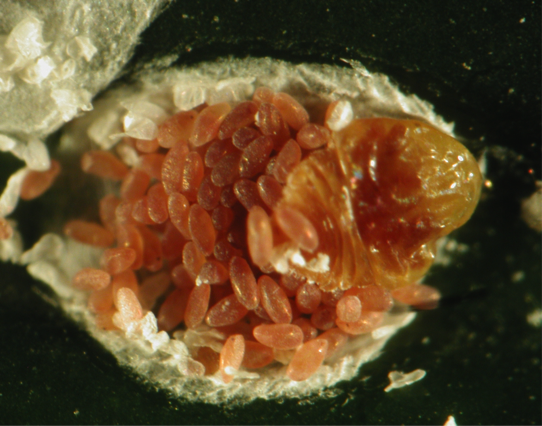
The Cycad Scale – A New Invasive Species to the St. Vincent
There is an alien species lurking inside our Botanical Gardens and across our landscape. Have anyone…